Lillooet South FSR
Sea To Sky Natural Resource District
Distance
24.09 km
Last Road Report
Jul 19, 2026
Closures
No Posted Closures
Location
Lillooet South FSR
Permit Holder
District Manager Squamish (dsq)
Waypoints
Distance
24.09 km
Avg. Gradient
0%
Ascent
0m
Descent
0m
Last Road Report
Jul 19, 2026
Closures
No Posted Closures
Location
Lillooet South FSR
Permit Holder
District Manager Squamish (dsq)
Waypoints
Conditions
Start to 2.0 km
Good Condition
11d ago
2.0 to 15.0 km
Somewhat Degraded
4d ago
15.0 to 24.1 km
Good Condition
37d ago
Notices
Gate Permanently Locked at 24km
Gate at ~24km (Perkins Creek) is closed year round to all public access, for public safety reasons and to minimize negative environmental impacts from unauthorized use at Meager Hotsprings. See public closure notice. 24km is the end of the public FSR.Source: https://www2.gov.bc.ca/assets/gov/farming-natural-resources-and-industry/natural-resource-use/resource-roads/local-road-safety-information/sea-to-sky/lillooet_south_fsr_closure_24km.pdf
Description
Gate is typically closed during the winter time and then subject to Wildlife Act road closures during spring and fall,This road is susceptible to frequent closures due to rising water levels and landslide risk from the Mount Meager complex. See: https://www2.gov.bc.ca/gov/content/industry/natural-resource-use/resource-roads/local-road-safety-information/sea-to-sky-natural-resource-district-road-safety-information/road-conditions-in-sea-to-sky-district for extra details
Road Bulletins
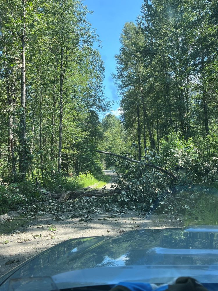
Several large tress down across the road between km 4-15, largest being roughly ~40 inches in diameter. Some were small enough to cut but a few required makeshift bridges/driving into the adjacent swamp to pass. Would not recommend driving at this time until road is cleared, unless you own a large chainsaw and have a winch on your vehicle!
Gate dummy locked at km 2 but otherwise open. Very recently graded and smooth sailing for any car with medium clearance. Couple of spots where the adjacent swamp overflows but is shallow

Seasonal gate was already unlocked as expected. Second gate at 24 km still locked as expected. Thin layer of slush covering the road which was otherwise in good condition, just some potholes. Same when leaving on December 7. Temperature was -2°C so expect this to be iced over or snowed in soon, needing chains. IIRC this road doesn’t get plowed in winter so eventually it’s impassable without snowmobile. Did not encounter any rangers before or after the permanent gate.

Road is great shape till ~2.4 km where there is a seasonal gate according to the sign (see photo): locked April 1st to June 15th & September 1st to November 30th as per the closure in road description

Generally 2wd friendly and well maintained, no waterbars, a number of fallen trees along the route which have been cut to allow passage, a fair few fallen rocks on the road but with a subaru no problems clearing them all. Beware animals jumping onto the road when driving in the early morn/at night, saw 2 moose, one of which jumped right in front of the car from the bushes with no warning.