Greg Jones
Status: Admin
Join Date: Apr 23, 2024
Location: Crowsnest Pass
Contribution Points: 1572
(6 points each)
(2 points each)
Recent Contributions

Drove to the BC Parks A-Frame at 21.5 KM in a Tacoma. Nothing too difficult, but a narrow road that you would not want to meet another vehicle going u...
Greg Jones - Sep 06, 2020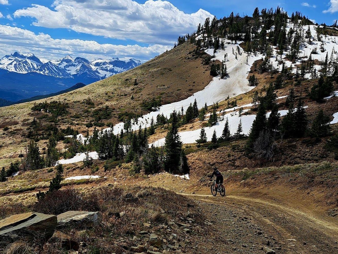
Road is gated at its start with HWY 3. We biked it to the Ma Butte Telecom Tower. Pushed bikes though Nez Perce Creek at ~7 km. Expect OHV traffic fro...
Greg Jones - Jun 12, 2026FORSYTH CREEK
57dThis road is generally good until the end plotted here, which is the unbridged crossing of Quarrie Creek. The road beyond to the old well pad can be c...
Greg Jones - Oct 21, 2025This road is usually kept in good condition to the rec site. Did it in a Tacoma, but passable in most vehicles when the snow melts
Greg Jones - Jul 03, 2025POPLAR CREEK
99dCascade Creek 1
99d

Road is gated and closed to motor vehicles from its start point in Elko. Easy to walk or bike up to get to hiking trails/old roads that lead to scenic...
Greg Jones - Apr 03, 2026FLETCHER LAKE
132dRoad was somewhat overgrown and had awkward cross ditches. Drove 1 km to Fletcher Lake Trail
Greg Jones - Jul 10, 2025FLETCHER
132dTURNER/DUNN
133dFriend drove to the north trailhead for Kuskanax Mountain at roads end. Reported decent HC 4x4 shape. The lower section of the road below Mt Abriel is...
Greg Jones - Jul 21, 2025DUNCAN-WESTFALL
133dThis road was fully deactivated and the bridge over the Westfall River at 0.4 km was pulled about 10 years ago. All subsequent bridges and crossing up...
Greg Jones - Mar 02, 2026MURRAY CREEK
133dDrove this road ~4 km to the Whitewater Creek Trailhead. Good 4wd condition
Greg Jones - Sep 30, 2025REDFISH-LAIRD
135dDrove this road to the Ross lake Trailhead. Decent HC 4x4 shape to 11.5 km.
Greg Jones - Aug 26, 2025DUNCAN-DEEP CR
142dThis road system has been long gone for over 30 years. Bridge over Glacier Creek at the start was removed in the process.
Greg Jones - Mar 02, 2026ADAMS-TUM TUM
160dDrove from Adams Lake/Holding rd to Tumtum Lake. Good shape but a long haul, bring full size spares
Greg Jones - Jul 02, 2025Road is its usual potholed and mud puddle mess until the barricade at 5.6 KM. The creek crossing at 0.6 KM is dry and fine for any HC 4x4
Greg Jones - Jul 10, 2023Oldman River Road
160dRoad is fantastic to 19.5 km, then a little rough (LC 4x4). We drove to 23 km, and there is a newish bridge over Slacker Creek. Did not drive beyond t...
Greg Jones - Sep 28, 2025Wintering Creek FSR
160dDrove this road to the bridge over Wintering creek at 13 km. Good 2wd condition
Greg Jones - Oct 06, 2025Vicary Creek FSR
160dENTERPRISE CREEK ONE
161dIdaho Lookout Road
161dRoad has been closed since 2020 floods/washouts. Locals groups continue to encourage gov't to rebuild.
Greg Jones - Feb 11, 2026A friend drove this road to access Soderholm. He says it was in reasonable shape to the bridge at 5.5 km. That bridge has been pulled but looked passa...
Greg Jones - Oct 01, 2024WHITE-EDWARDS
161dDrove this road in 2023 and it was in good shape to 11 km. It was HC 4x4 beyond this
Greg Jones - Jul 11, 2023WHITE CREEK
161dFrom MoF: "ATV bridge at 12.4km is closed due to rot in all wood components."
Greg Jones - Feb 10, 2026Doctor Creek FSR
162dRoad is in good 2wd shape to ~15 km, then HC 4x4 to 17km, then somewhat impassable in a stock truck
Greg Jones - Oct 01, 2024PORTMAN CREEK
162dMARK CREEK
162dFrom MoF: Closed to non-industrial traffic. This closure, and accompanying gate, was approved to protect public health and safety, and to reduce the r...
Greg Jones - Feb 10, 2026DEWAR CREEK
162dRoad was fine for a Tacoma to the Dewer Creek Trail. Rough and long though
Greg Jones - Oct 01, 2025RICHMOND LAKE
163dRoad was a bit rougher and narrower than Perry Creek FSR to the Goldrun/Richmond Lake TH at the end.
Greg Jones - Aug 26, 2024Perry Creek Main
163dSPRING CREEK
163dDrove road to the Plaid Lake/Mt Crawford TH at ~6 km. HC 4wd recommended in the last 2 km
Greg Jones - Aug 04, 20254-23 Alexander Creek
170d
This road is open June 16 to March 31 annually. It currently has snow on it, but looked fine up to 3 km.
Greg Jones - Feb 01, 2026Phillips Pass Road
194dRoad is accessed 1 KM west of the BC/AB border at the pullout at "Crowsnest Park" and is walk/bike only. This road can't be accessed from the east/Alb...
Greg Jones - Oct 16, 2025Racehorse Pass Road
194d
There are significant water trenches that run down the road right near the start that will keep most stock 4x4 out. We walked up to the pass amongst a...
Greg Jones - Aug 28, 2021Pinto FSR
215dBRUCE-RYAN
215dBUGABOO-TEMPLETON
215dRoad has been getting brushier in the last few years. Drove to 9 km in a Tacoma and hiked to Templeton Lake
Greg Jones - Jul 24, 2024SPILLIMACHEEN-MCMURD
218dDrove this road to the Silent Pass TH. Good shape to 9 km, and then 4wd HC to end
Greg Jones - Sep 20, 2023Road to Lille
229dGood shape to the parking lot at 3 km, OHV/bike/hike only beyond this point.
Greg Jones - Nov 11, 2025Frank Wellpad Road
229d
From HWY 3 road is paved to the Frank Slide Interpretive Centre, and then HC 2wd to 3.5 km. Road is HC 4x4 beyond.
Greg Jones - Nov 04, 2025CBC Tower Road
249dA67 PAUL CK BR 2
268dRoad was good to the end, and the trail to Dainard Lake. Some waterbars are bigger than others, but all relatively easy
Greg Jones - Jul 27, 2024Wolverine Pass FSR
268dFRANCES CREEK
268dCoal Creek Road
268dGood shape to Matheson FSR at ~10 km, did not drive beyond, but looked to be fine.
Greg Jones - Oct 01, 2025GOAT HAVEN 44
268dThe way the road is plotted here, you can drive to 2.2 km to a gate at the creek/bridge barring all access into the road systems into North Galbraith...
Greg Jones - Sep 25, 2022Chauncey Creek FSR
268dThis is the Chauncey Creek FSR. This road and the Todhunter FSR share the same start point. This road is in good shape for driving until it starts up ...
Greg Jones - Apr 24, 2024Mause Creek FSR
269dRoad was in good condition to the Mount Fisher trail at 10 km, and then a bit rougher to the Mause Creek Trail at roads end.
Greg Jones - Oct 13, 2021WHITE-MOSCOW
269dRoad was in good condition to the White-Edwards jct. Did not drive beyond this point, but looked decent.
Greg Jones - Aug 18, 2024WHITE-PTARMIGAN
269dRoad is intentionally blocked at 0.7 km. The rest of the road is now the Ptarmigan Lake Trail.
Greg Jones - Aug 18, 2024WHITE-NORTH FORK
269dDecent condition to the bridge('s) out at 34.5 km and 35 km. Impassable beyond.
Greg Jones - Sep 16, 2024R08359 SEC.28
270d

Grassy Mountain Road
270dRoad is gated just past the golf course entrance. Northback Mining owns the land beyond and has gated the road.
Greg Jones - Oct 21, 2024Coseka Resource Road
270dGood condition to 8.3 km. Gated at that point and no vehicular access beyond
Greg Jones - Oct 06, 2024
Howell North FSR
272d
If you were able to limp a HC 4x4 up the Howell FSR, you may as well drive this road for ~1.5 km to the creek crossing. The culvert is still sitting t...
Greg Jones - Aug 03, 2024Howell Creek FSR
272dCoal Road
272dRoad is driveable to just past East Crowsnest Creek. No access to Tent Mt (private property)
Greg Jones - Jul 29, 2024BULL/QUINN CK
279dI drove this road through to the Blackfoot FSR in 2016, but this video in 2021 suggests it is not driveable at what I believe is the 9 km mark.
http...
York Creek Road
280d
Bridge at 4 km over York Creek has lock blocks placed across barring access any further by anything larger than a dirt bike.
Greg Jones - Oct 15, 2025Hailstone Butte Road
286dThe road is gated at the start. We biked the road and went up Hailstone Butte. The road gives access to Plateau Mountain and Salter/Pekisko Pass area ...
Greg Jones - Oct 16, 2019
Road is gated at the start. There is another gate at ~4 km that I drove to in 2020 in a Tacoma. There is no signage or indication as to when the gate ...
Greg Jones - Oct 03, 2025Savanna Gas Road
286d

Road is in good condition to the locked gate at 1 km, then biked to end of road at gas site. Great road for biking, but a lot of very large bear dropp...
Greg Jones - Sep 19, 2023Savanna Creek Road
286dWildhorse Main
295dRoad is in decent condition to the Bear Lake Spur at 16 km. The bridge that washed out last year at 10 km has been fixed. Don't expect to drive more t...
Greg Jones - Sep 29, 2025WILDHORSE/BEAR LAKE
295dRoad was in decent shape, although I would probably recommend HC 4x4 for the last 2 KM getting to the Bear Lake TH.
Greg Jones - Sep 29, 2025Alexander Creek FSR
331dCanfor is very busy in the Alexander drainage this year, so the road is in the best shape I have ever seen it. Drove to 18.5 km (close to the end). A ...
Greg Jones - Aug 24, 2025GOLD CREEK
336dAfter the huge Adams Lake fire, they have built a new section of road that now connects this road to Rawson Road at the lakeshore. I drove 7 km to a n...
Greg Jones - Aug 16, 2025Davis Lake Main
337dThis road is gated at its entrance at the Comox Lake Rd. It is used heavily to access mountain bike trails and forest harvesting activities for the co...
Greg Jones - Aug 19, 2025Allison Creek FSR
359dDrove to 18 KM. Road seems in rougher shape after large July rains with large potholes for basically its entire length. Very very busy with OHV traffi...
Greg Jones - Jul 27, 2025Todhunter Creek FSR
373d
Drove Todhunter FSR to climb Mt Gass. This road is only open June 15th to Aug 31st every year. The gate at the start gets locked outside of those date...
Greg Jones - Jul 13, 2025R08389 SEC.04
415dRoad has the first ~200 m completely dug up and re-sloped. We pushed bikes through this and then found the road in good biking shape to the end/highes...
Greg Jones - Jun 01, 2025HORSETHIEF CREEK
475dGood shape to Lake of the Hanging Glacier trail at roads end. A few rough spots
Greg Jones - Aug 10, 2021Monica FSR
491d
Drove to Monica Meadows trailhead with no difficulties. Subaru and Sprinter van in parking lot as well. Couple of waterbars might be tricky for LC 2wd...
Greg Jones - Aug 04, 2020

Road is designated non-motorized (snowmobiles allowed in winter). You can ride a bike to 3 km comfortably. After that you are pushing the bike for the...
Greg Jones - Sep 04, 2024
Lost Creek Road
566dYork Creek Road
576d2wd to the York Creek Staging Area at 3.5 km. Rough 2wd from staging area to bridge at 5.5 km. HC 4x4 beyond
Greg Jones - Oct 20, 2024
Range Road 303
576dRoad is gated at 9 km. Not the road to take if you are approaching the Front Ranges. Always use RR 43 to Pecten/Waterton Gas complex.
Greg Jones - Dec 23, 2024Gated at 1 km. Do not approach this road from south (assertive private property owners). Approach from the north, via Shell Waterton/Butcher Lake.
Greg Jones - Oct 23, 2024Good shape to the end that is plotted here (~11 km). after that all bridges, including the first one over the Carbondale River are OHV width
Greg Jones - Jul 29, 2024PHILLIPS CREEK/MAIN
651dOldman River Road
655dButter smooth to Honeymoon Creek at ~15 km. Traditionally, this road is usually in decent condition to the dilapidated bridge over Slacker Creek at 22...
Greg Jones - Oct 05, 2024Summit Lake FSR
667d
I drove a Tacoma to ~6 km (1800 m). Road has numerous new waterbars that have been created every ~100 m. They are deep and sharp and took some patienc...
Greg Jones - Sep 21, 2024Upper Flathead FSR
667d


From Corbin townsite, we drove a Subaru south to the washout at 10.5 km. If you have a HC 4x4 you can very carefully drive the heavily washed-out road...
Greg Jones - Sep 22, 2024Hillcrest Mine Road
670d

You can open the gate at the start of this road (lock back up) and drive to the firebreak at 1.7 km. Some big mudholes and craters in the road should ...
Greg Jones - Sep 01, 2024Big Rock Road
701dWe biked road to climb Peak 2690 (Darrah S2). Its rideable 50% of the way up, and 100% of the way down
Greg Jones - Aug 18, 2024Flathead FSR
702dBarnes Lake FSR
702dDrove road to the end, decent condition for a Tacoma. Block and road layout ribbons indicates more logging may occur in this valley in the near future...
Greg Jones - Aug 17, 2024Upper Flathead FSR
702dFrom Corbin, this road is in good shape to the Barnes Lake turnoff at 4.5 km. After that it deteriorates, but was in decent shape for us to get a Suba...
Greg Jones - Aug 18, 2024Lynx Creek Road
722dRoad is managed by the province. Good shape from Blairmore to the Carbondale River
Greg Jones - Jul 29, 2024Ptolemy Creek FSR
722dThis is the trail up to the "Promised Land", also known as "7 Bridges Trail". Expect ATV traffic and 7 crossings of Ptolemy Creek (no bridges).
Greg Jones - Jul 29, 2024Leach-Taylor FSR
774d(From Steve Noel) Drove via the Leech FSR . A few washouts are starting, fine in a stock SUV for now but only a major storm away from being challengin...
Greg Jones - Jun 03, 2024BUGABOO-SOUTH
793d
In great shape to the landing, just ~200 m from the Silver Basin TH. The bushy nature of the road spoken of in guidebooks is nowhere to be found right...
Greg Jones - Aug 30, 2019Alexander Creek FSR
797d
This is the Alexander Creek FSR (it continues to its conclusion at the old well pad at 49.806399,-114.707570). Drove road to the end to climb Secord a...
Greg Jones - Oct 11, 2022Westroc Mine Road
800dWindermere Creek FSR
800dRoad is in good shape, albeit a bit rocky to about 1 KM before the end of the road (~8 km), and the Pedley Ridge/Pass trail. From there its probably ...
Greg Jones - Aug 09, 2021Welsh Lakes Spur
800dNo brush at all like there has been in previous years, but still HC 4x4. Crosses 2 prominent rock slides, so it might be a good idea to have something...
Greg Jones - Sep 27, 2022DELPHINE
800dRoad is in ok shape to only ~2 km and the Mount Nelson trail/route. Impassable beyond this point.
Greg Jones - Oct 08, 2023WHITE BOAR
800dThis road was narrow and HC 4wd, but quite doable to White Boar Lake. At the 16 KM sign on the Meachen Creek FSR, take the left fork and drive the na...
Greg Jones - Oct 13, 2018Farnham Creek FSR
806dRoad was in ok shape to the very sketchy bridge at 14 km. There were make shift 2x4's and planks that folks had brought up to patch up the rotted brid...
Greg Jones - Oct 01, 2021Boulder Creek FSR
807dDrove this road to the big switchback at 13 km. Was a bit rough after it leaves the Wallinger FSR jct.
Greg Jones - Jul 19, 2022White Ram
807dRoad is driveable to the Marmalade FSR at ~10 km. No motorized traffic allowed beyond.
Greg Jones - Oct 16, 2023Wildhorse Main
807dDrove this road to the outfitters camp at 25 km. Road becomes very rough after that
Greg Jones - Oct 04, 2021WILDHORSE/BEAR LAKE
807dMeachen Creek FSR
809dBLY SEC.36
809dRoad was being roughed in by an excavator, and was very drivable (probably HC 4x4) to 1.5 KM. I actually parked a few KM away on the Collie Creek Road...
Greg Jones - Aug 17, 2019SWANSEA MOUNTAIN
809dRoad is drivable to the top by HC 4x4, and good for minivans as well apparently. Tight switchbacks, narrow in spots, and loose surface. Would be chall...
Greg Jones - Sep 19, 2022BOOTLEG CREEK
809ddrove to the last switchback (at nearly 6000 ft) because we rode "Snow Mexican" trail. We did this in a Tacoma. This steep road system gets a lot of l...
Greg Jones - Jul 04, 2021BREWER CREEK
810dSummit Trail Makers Society cleared the road of trees and some avy debris on route to doing some early season trail maintenance.
Greg Jones - Jun 30, 2021DUNCAN-GLACIER CR
810dKINDERSLEY-PINNACLE
810dGood shape to end and the Diana Lake Trailhead. HC recommended for a couple spots,
Greg Jones - Sep 28, 2023Window Mountain Spur
810d
Road was in typical shape to the end. It's pretty simple, if you have a 2wd, don't drive this road and park on the Allison Creek Road (lots of space)....
Greg Jones - Sep 12, 2023Frisby Ridge FSR
811dSale Mountain FSR
811dI drove this road to the top and rode my DH Bike down the committing Martha Creek DH Trail. Road was in good HC 4x4 shape
Greg Jones - Aug 04, 2020KEYSTONE / BR B C
811dDrove this to do Keystone-Standard Basin. Was clear and good for Tacoma. Saw other LC 2wd vehicles high up the road
Greg Jones - Aug 07, 2019Dry Creek FSR
811dThis is the Dry Creek FSR. Great shape to the gate. The Line Creek Mine starts at the end, as does the Dry Creek Trail.
Greg Jones - Sep 30, 2021