Squamish River Branch 250
Sea To Sky Natural Resource District
Distance
2.50 km
Last Road Report
Sep 13, 2026
Closures
No Posted Closures
Location
Squamish River Branch 250
Permit Holder
Northwest Squamish Forestry Ltd.
Waypoints
Conditions
Start to 0.2 km
Somewhat Degraded
30d ago
0.2 to 2.5 km
Heavily Degraded
37d ago
Description
This is the access branch used to reach the Tricouni Peak trail head.
Road Bulletins

Distance Travelled
10.10km
The washout has been very well repaired and is was easily doable by 4runner. Road is in great condition until the first turn off and then it degrades rapidly and gets overgrown. I was able to make it to the upper parking lot with no problem, except for brutal pinstripes.
Distance Travelled:
1.24 km

Modes of Travel
Distance Travelled
10.10km
Same as previous report. Added picture showing the view of the washout looking back towards the parking area.
Modes of Travel:
Distance Travelled:
0.22 km
Modes of Travel
Distance Travelled
10.10km
The "impasse" with logs has been repaired to 4x4 standards. Whoever repaired it did a very good job. Past that point road becomes grown in and you should not care about your paint if you want to keep driving all the way to the trailhead.
The end of the road is actually a bit further than shown here on the map. 1km and 140m elevation further. Not sure why it ends before the actual parking lot and trailhead. Total length should be about 3.5km.
The end of the road is actually a bit further than shown here on the map. 1km and 140m elevation further. Not sure why it ends before the actual parking lot and trailhead. Total length should be about 3.5km.
Modes of Travel:
Distance Travelled:
2.50 km
Distance Travelled
10.10km
Same as reported. Did not attempt driving across the logs, but the ones on the left shifted quite a bit while walking across. There is room to park ~3-4 vehicles (maybe more) close to the washout and still leave room for folks to turn around.
Distance Travelled:
1.28 km


Modes of Travel
Distance Travelled
10.10km
Made it up to the start of 250 easily in my Nissan XTerra. Lots of vehicles parked at the pull off. Did not trust the log bridge so we hiked from washout at 7.5 km from Branch 200 to the end of 250. When we reached the end of the branch, there was only one 4Runner brave enough to cross the log bridge.
I’d imagine most high clearance 4x4s would not have a problem with the remainder of the road if you can get past the washout.
I’d imagine most high clearance 4x4s would not have a problem with the remainder of the road if you can get past the washout.
Modes of Travel:
Distance Travelled:
2.50 km

Modes of Travel
Distance Travelled
10.10km
Branch 200–250 is steep/rocky but fine in an SUV with care and good tires.
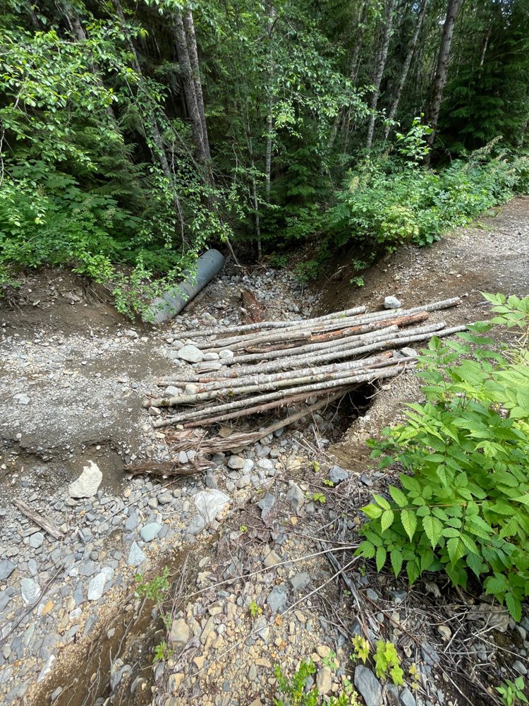
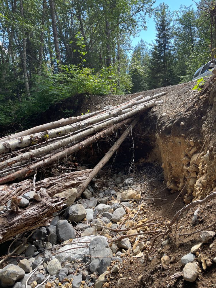
I crossed the log bridge on 250, so here’s a guide for anyone daring enough to try. I assume no liability for your risk and still don't recommend it. You’ll need a spotter, 2–3 ratchet straps, and aired-down AT tires. Check every log since they shift after each crossing. A strong green log is the safest tire contact and should be your spotter's baseline. The other side has smaller unstable logs and should be strapped around. Gas it lightly and steadily (sudden throttle will push logs into the hole). On the return, don't turn left too early or your rear tires will fall off the logs. My 4Runner is pretty narrow, and even then the bridge was barely wide enough.
Beyond the bridge is rough and will pinstripe your car, but with clearance you can do it (sinkhole is passable and water bar needs HC). Good luck!
I crossed the log bridge on 250, so here’s a guide for anyone daring enough to try. I assume no liability for your risk and still don't recommend it. You’ll need a spotter, 2–3 ratchet straps, and aired-down AT tires. Check every log since they shift after each crossing. A strong green log is the safest tire contact and should be your spotter's baseline. The other side has smaller unstable logs and should be strapped around. Gas it lightly and steadily (sudden throttle will push logs into the hole). On the return, don't turn left too early or your rear tires will fall off the logs. My 4Runner is pretty narrow, and even then the bridge was barely wide enough.
Beyond the bridge is rough and will pinstripe your car, but with clearance you can do it (sinkhole is passable and water bar needs HC). Good luck!
Modes of Travel:
Distance Travelled:
2.50 km
Distance Travelled
10.10km
The washout is still there, and more logs were added for a more stable footbridge but definitely not safe to drive over. The damage is quite extensive (~6ft deep, ~15ft long). I wouldn't count on this being repaired soon.
Distance Travelled:
2.50 km


Distance Travelled
10.10km
New washout at the same location as the original, basically impassable with all but the most burly 4x4s. As of writing, there is a 4-foot-tall vertical bank to descend, then you must immediately climb over a 2-foot-tall log and up the other bank. Lots of trees are down after the washout, and a saw will be needed to clear them.
Snowline started 2km up the road after the washout.
There is good parking at the washout, and a poor footbridge over it.
Snowline started 2km up the road after the washout.
There is good parking at the washout, and a poor footbridge over it.
Distance Travelled:
0.08 km
Distance Travelled
10.10km
Was able to make it past the washout in a stock 23 Tundra. Undercarriage and bumpers touched down especially back bumper on return trip. Seems pinstripey but paint job looks fine afterwards.
Distance Travelled
10.10km
I'll have to disagree with the latest posting and confirm that the ditch is still quite difficult. I couldn't do it with my 2010 lifted rav4 due to traction issue. Only saw jeeps and tacomas at the real trailhead
Distance Travelled
10.10km
Went for a drive after work to test a friend's new rig. Have heard it's worse than it used to be, but it wasn't that bad. A good crossover can still get to the trailhead. The big washout is deep but wide, so bumpers won't get crunched too easily. Beyond that, there are some ruts and holes, but open diffs are fine with any modern traction control system. Overgrowth is not pinstripy yet, just a little annoying at worst. If you can get to this branch, you're probably good to get all the way tbh. The branch 200 section has actually degraded over the last couple years, more so than this
Distance Travelled
10.10km
The impasse at 700m has eroded and there's a large patch of loose dirt on the far side. Some Ford F150s made it across but most cars parked before the washout. Past that it's in good shape for a couple more kilometres, then reaches a large hole which would be difficult to avoid.


Distance Travelled
10.10km
Thought i'd say it isn't impossible... Made it to the end of the spur for a Tricouni hike, pretty doable in something like a suzuki sidekick. Made it up in a stock clearance tacoma but barely squeezed across a semi-washed out bridge around 2km, there’s plenty of parking space right before that bridge for rigs that made it through the washout but too wide to squeeze past. A few other manageable drainage ditches along the way and it gets pretty rocky and bushed-in during the final stretch up to the parking. If you plan to go past the first washout, I hope you aren’t worried about pinstripes! (At least in the summer)
Distance Travelled
10.10km
Impasse has been filled, easily made it through with a stock 4runner and some momentum. Pin stripping gets bad near the top, if you care about this stop and walk the rest (extra 15-20min each way).

Distance Travelled
10.10km
Katrina Kuba posted on Facebook in the Squamish Ski Mountaineering & Mountain Running Club, that this branch has a washout right at the start of it. This is the road to Tricouni