G-Main
Sea To Sky Natural Resource District
Distance
24.33 km
Last Road Report
Jun 21, 2026
Closures
No Posted Closures
Location
G-Main
Permit Holder
Northwest Squamish Forestry Ltd.
Waypoints
Distance
24.33 km
Avg. Gradient
0%
Ascent
0m
Descent
0m
Last Road Report
Jun 21, 2026
Closures
No Posted Closures
Location
G-Main
Permit Holder
Northwest Squamish Forestry Ltd.
Waypoints
Conditions
Start to 0.1 km
Somewhat Degraded
32d ago
0.1 to 4.2 km
Good Condition
550d ago
4.2 to 12.5 km
Somewhat Degraded
689d ago
12.5 to 24.3 km
Impassable
689d ago
Description
No description.
Road Bulletins
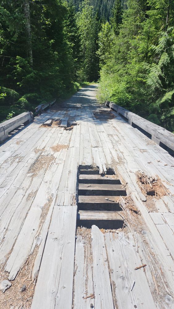
Holes in bridge at start have gotten worse than last year. Attempted to cross in my Pilot, but chickened out at the last bit. Some people parked at the start and hiked in, others like a Tacoma and ATV just drove over anyway. Had to back out over the remaining holes.
No road condition change from previous reports, but Bierman Creek is running very high right now so the water crossing at 8km is treacherous. We met a chap there who informed us that the G-Main may be fully restored up to Sims Creek, with work possibly starting in July. Big if true.

Just adding a photo of 8 km creek crossing. Obviously didn't attempt in my Pilot. Watched some workers manage to pull a giant camper trailer across in a pickup though, albeit with a little struggle. Can't remember which bridge had some holes in it.


Good condition, but quite deep snow up to the 4.5km mark. I would not have driven this far if not for some existing tracks to follow. On the drive back it appears some group has driven beyond the 8km mark and so there’s tracks at least that far. The snow is firm most of the way but there are some looser powdery sections


Road is driveable with medium-high clearance until 10.6km where there’s a very big fallen log. Only an SUV could fit under this, after which point you can drive another 2km or so to a very large impasse.
Bridge at 2km mark is reportedly back in and road is AWD condition up to Bierman Creek (~8km)


old bridge has been washed out - from another POV. suppose maybe moto could get across, but the boulders on the other side makes me think that might be pretty hard. Road otherwise seems like its been plowed up until that point. snow on the sides of the trail, but otherwise wet and a bit mushy between the snow.

Went up the Elaho G-Main past peaches and cream falls to (50.2251626, -123.5763514) where the stream has diverted down the road. Seems to be the farthest up you can go for now. Would be interested if the Elaho Mainline is grated anytime soon. Hope this helps.

[From Douglas Vis] - The road is washed out 8.5km from the start of the Bug Lake Trail head. About 50m of the road is now a creek. At ~12.5km from the start of G-Main.